
The Explore Subcommittee gathers information from publicly available sources to evaluate how waste impacts the borough of Queens. We are currently engaged in an ambitious project to create a comprehensive report titled The State of Waste in Queens. We welcome the participation and contribution of outside researchers, community advocates, and activists to help us understand the questions that are of most interest to local stakeholders. The map at the top of this page highlights information from DSNY’s Solid Waste Management Plan focused on municipal transfer stations. Recently the QSWAB created its own map of waste and resource-recovery sites in Queens. This is a still-evolving project for which we welcome feedback. To suggest a resource to add to the map, email us at queensswab2019 at gmail dot com.
Other maps regularly updated with current NYC information, include the following examples:
- Pharmaceutical and Syringe Drop-Off Locations in New York City:
[googlemaps https://www.google.com/maps/d/embed?mid=1J3RJz4DvoW05qdndV8Eoowf3QtQIQ8Zb&w=640&h=480]
- Big Reuse’s Food Scrap Drop-Off Locations:
[googlemaps https://www.google.com/maps/d/embed?mid=10vuwAe-QXo_IH2jH_9oiUHr1etU&w=640&h=480]
- DSNY Residential Food Scrap Drop-Off Locations:
[googlemaps https://www.google.com/maps/d/embed?mid=1oMdEEzEuacc9pbwDTJTBbDiaQHI&w=640&h=480]
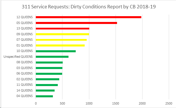
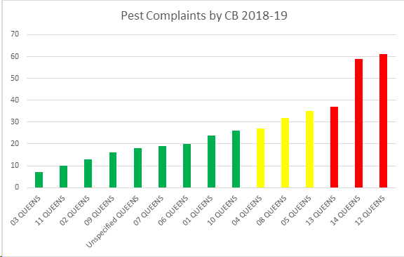
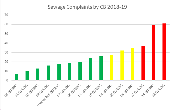
To make a difference in the amount of waste generated, stored, collected, transferred, and transported in our borough, we first need to educate ourselves about it. The charts below were created around the time we formed to provide an overview of waste’s impact — not properly addressed or seen as a resource — on Queens residents. The information was gathered from NYC Open Data.

Find us on Twitter  Follow us on Facebook Connect with us on Instagram